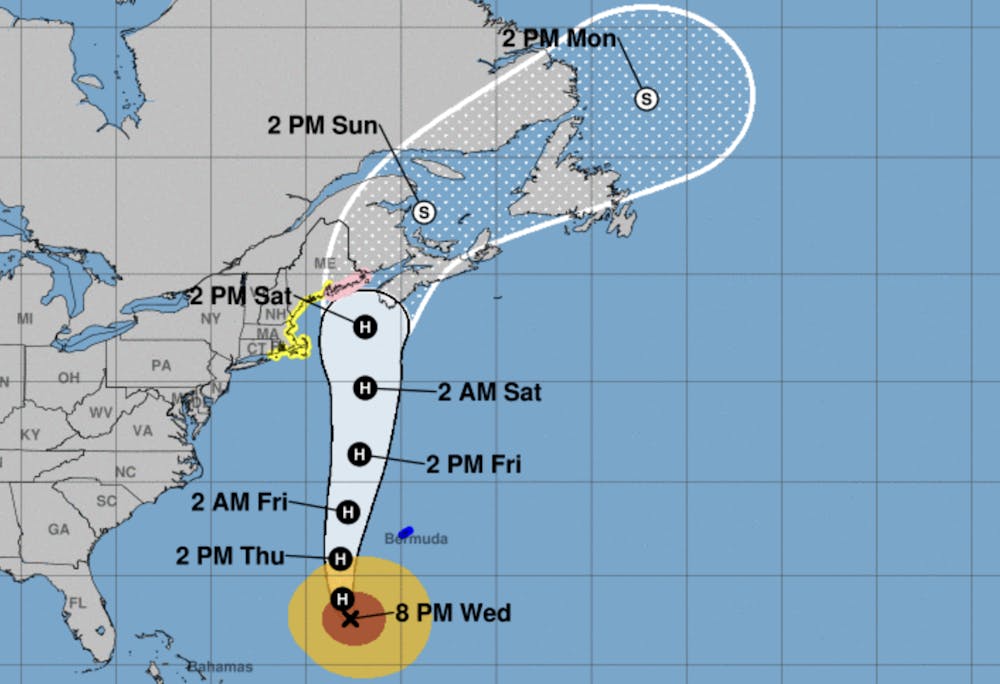
Hurricane Lee is expected to bring heavy rain through New England as the Category 2 storm expands in size, potentially sparking flash flood warnings and shelter-in-place recommendations. The third major hurricane of the 2023 Atlantic hurricane season, Lee formed on Sept. 5 from a tropical depression prompted by a tropical wave that shifted off of the West African shore and into the tropical Atlantic a couple of days prior.
Predictions show the storm reaching the coasts of New England and Atlantic Canada on Friday night into Saturday morning, bringing dangerous rip currents to the regions, with parts of the Rhode Island coast under a tropical storm watch.
Lee began churning about 380 miles south-southwest of Bermuda with winds up to 105 miles per hour, according to the Associated Press. The storm is expected to hit Bermuda at some point Thursday as of the publication of this article, extending into Friday morning, with heavy rainfall and hazardous winds. After passing through Bermuda, Lee is expected to continue growing in size and moving northward.
While the storm is only a Category 2 hurricane as of Wednesday night, its size makes it especially notable. Because Lee is so large, hazardous storm conditions like heavy rain, extreme wind and flooding are expected even in areas far from its center. Although the storm is expected to make landfall anywhere between Maine and Nova Scotia, New England is at risk of severe flooding, the New York Times reported.
Over the weekend, parts of the Northeast — including Rhode Island, Massachusetts and Connecticut — were hit with bouts of heavy rain, resulting in flash floods and significant damage. According to The Weather Channel, Lee’s heavy rains could worsen the state of flood damage in New England, with forecasters warning of downed trees and power lines from the storm’s winds. Shortly before 5 p.m. today, students at the University also received an emergency weather alert for a tornado warning as sirens blared outside.
Earlier this week, The Herald reported on several instances of dorm floodings and leakages following days of heavy rainfall. The University has a hurricane protocol available online to students.

Sofia Barnett is a University News editor overseeing the faculty and higher education beat. She is a junior from Texas studying history and English nonfiction and enjoys freelancing in her free time.